Published by Guest Blogger. Last Updated on February 16, 2022.
Disclaimers: Our site uses demographic data, email opt-ins, display advertising, and affiliate links. Please check out our Terms and Conditions for more information. Listed prices and attraction details may have changed since our visit and initial publication.
The Pacific Crest Trail (PCT) is an epic long-distance footpath that traverses some of America’s most spectacular wilderness areas. The PCT was designated as a National Scenic Trail in 1968 and stretches for 2650 miles (4265 km) in length.
Many backpackers and adventurers dream of hiking the Pacific Crest Trail in a single season, a feat known as a “thru-hike”.
Hiking the entire trail is not for the faint of heart, however. The PCT stretches from Mexico to Canada along the spine of the Sierra Nevada and Cascade mountain ranges. A typical thru-hike takes approximately 5 months and requires hiking 20+ miles (32+ km) every day.
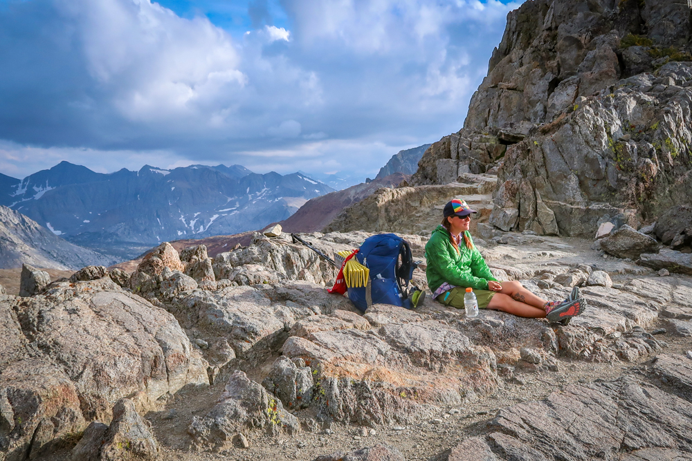
Thru-hikers spend months in the wilderness and encounter all sorts of complex (and often dangerous) challenges. They must meet nature on its terms and push themselves to the absolute limit of their endurance.
Most hikers who start the PCT do not finish it, whether due to illness or injury, or other unforeseen circumstances.
But for those who hike this stunning trail, whether they finish it or not, the experience is a life-changing one.
Highlights of Hiking the Pacific Crest Trail

The PCT passes through an amazing diversity of landscapes in the states of California, Oregon and Washington.
The journey begins at the border with Mexico an hour’s drive east of San Diego. These first 700 miles (1,125 km) traverse through the high desert in Southern California, passing highlights such as the Mojave Desert and Mount San Jacinto.
At Kennedy Meadows, the PCT enters the High Sierras. For the next 400 miles (645 km), the path travels through what John Muir famously called the “Range of Light”. In the Sierras, all of the trail exceeds an elevation of 6500 feet (2000 m) – with much of it over 10,000 feet (3,000 m). This section includes the highest mountain in the contiguous United States – Mount Whitney.

After the PCT leaves the High Sierras, the next 700 miles (1,125 km) travel through Northern California. Here, hikers encounter a mix of mountain landscapes – although at a much lower elevation. The section also features incredible views of Mount Shasta and some memorable trail towns.
The State of Oregon is the flattest and easiest part of the Pacific Crest Trail. PCT hikers frequently refer to this 500-mile (800-km) stretch as the “green tunnel” because much of it travels through gorgeous forests. Highlights of Oregon include Crater Lake National Park and Mount Hood.
The last section of the trail is Washington State. After crossing the Bridge of the Gods over the Columbia River, backpackers traverse the rugged alpine beauty of the Cascade Mountains. Highlights of Washington include the stunning Goat Rocks Wilderness and the remote village of Stehekin near the Canadian border.
When to Hike the Pacific Crest Trail

There is a narrow window of opportunity each year for PCT thru-hikers to complete the trail…when it is not entirely covered with snow.
Most northbound hikers aim to start hiking the PCT in March, April or May. The goal is to reach the High Sierras in June (or early July) – right when the snow has melted enough to make it through. Then it is a race against the clock to reach Canada before snow starts falling in late September or early October.
While most folks travel in the northbound direction, some opt to head south instead. Southbounders typically start in mid-June or July when the snow begins to melt in the North Cascades. Then they must hike quickly to the Sierras before the autumn snow storms begin.

So, which is better – northbound or southbound? That depends on the individual hiker and a number of factors such as the weather and personal preference.
Starting at the Mexican border has the advantage of an easier elevation profile. This gives hikers the chance to acclimate to hiking every day in less hilly (and less snowy) terrain.
Since most thru-hikers go northbound, this means it is the more social option. Northbounders are rarely alone and tend to gather together in groups. It is a great way to make friends and can be a lot of fun.
If you’re looking to miss the crowds, however, then heading southbound may be a better choice.
Planning for a PCT Thru-Hike

PCT hiking is something that typically takes months (if not years) of planning and preparation.
One important consideration is what to bring on the journey. PCT hikers travel as light as possible – because the lighter the pack, the less likely you are to get injured.
A typical PCT gear list includes the bare minimum of ultra-light backpacking gear. Most hikers strive for a base weight of under 15 to 20 lbs (6.8 to 9 kg) maximum. A pack’s base weight does not include food or water, so the final weight is typically higher.
Another factor of hiking the Pacific Crest Trail is what to eat and how to resupply. You must be able to travel for up to a week at a time in the wilderness and bring everything you need to survive.
A high level of fitness is required to hike the PCT. A regimented training plan is recommended before hitting the trail to ensure you can hike 20 miles (32 km) per day – with a full pack.

Staying in touch with family and friends back home can be another challenge. While some hikers keep a PCT blog or make updates on social media, this can be hard to maintain in the wilderness.
Many people opt to bring along a personal locator beacon such as a Garmin InReach Explorer to stay connected over satellite in case of emergency.
These are only a few of the many things to consider when planning a PCT thru-hike. Be sure to consult the Pacific Crest Trail Association website for more details and to obtain a PCT Permit.
All images were provided courtesy of A Rambling Unicorn.
✈️ Book Your Next Trip
- • Planning a trip? Find a flight deal.
- • In need of a room? Check out hotel and Airbnb prices.
- • Taking a cruise? Find a cruise itinerary for your journey.
- • Book a rental car or day tours to explore more as well!
- • Don't overlook travel insurance to protect your trip, too!